
Aerometrex has partnered with the City of Centennial to assist in enhancing its urban planning activities and communication with citizens. We spoke to Tanner Hurst, GIS Analyst at the City of Centennial to understand how the integration of 3D models has transformed the city’s planning processes and public engagement.
The City of Centennial aims to maintain open data and communication with its citizens while improving urban planning and resource allocation. The challenge was to provide a clear and comprehensive view of future developments and their impact on the community.
Aerometrex supplied high-resolution 3D mesh models for the City of Centennial, allowing them to expand their 3D GIS capabilities and improve public engagement.
The City of Centennial plans to launch a fully interactive 3D city model by early 2025. This model will enhance public access to city data and tools, support ongoing and future urban development projects, and improve transparency.
As the city’s 3D interactive model is still being built out, they have already identified numerous areas in which it will serve to enhance how they use GIS for internal and external purposes.
Aerometrex’s 3D solution has been a great product that’s expanded the horizons of our organization by starting us down the path to a 3D GIS system. Citizens will soon have a living, breathing model of their city both now, and in future configurations, at the tips of their fingers.
Tanner Hurst - GIS Analyst, Office of Innovation and Technology (OIT), City of Centennial
[OIT supports the city’s IT initiatives and serves as the main department that develops and maintains applications for staff and citizens.]
With the city’s new LDC (Land Development Code) amendment, developers for large projects are required to submit 3D files for use in the city’s model. The ability to slot developer models into 3D mesh scenes captured by Aerometrex gives the City of Centennial a new capability to understand what works, where and why. This integration allows planners to conceptualize the scope and scale of future developments and their impact on surrounding areas.
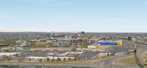
The image above shows an example of a large-scale future development slotted into the I25 corridor.
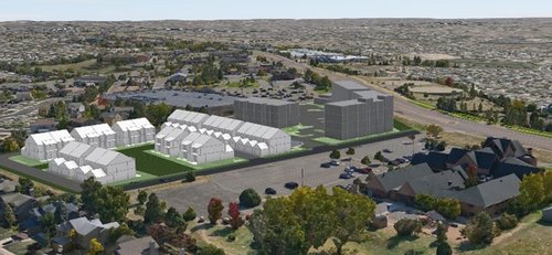
Planners can review how a new multi-family development would work in the context of the existing neighborhood and its infrastructure.
Using the 3D City Model, the Public Works team will be able to analyze variables that can impact their operations like ice accumulation due to shadows in winter.
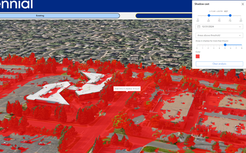
Integrating 3D developer models into pre-captured AOIs allows residents to see what is being built around them and how it impacts their lives, before construction even begins.
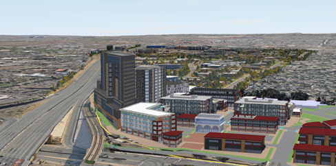
Using the models in conjunction with Esri’s ArcGIS Experience Builder, the city will be able to plug in developer models for use in public engagement helping them build planning transparency.
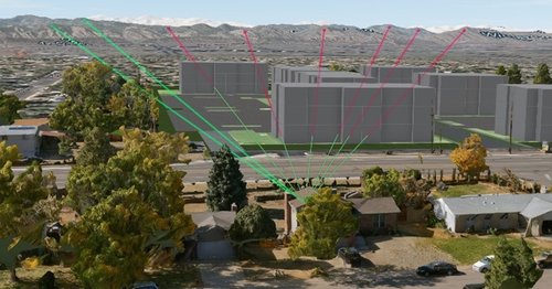
This analysis can show how new constructions impact residents’ views, helping to identify and mitigate potential issues early. This can also be used by city staff to identify residents who could potentially have pushback at public council meetings.
Image: Here, a line-of-sight analysis tool is used to show how a resident’s view from their house is impacted by the construction of a multi-story residential complex.
Providing access to the entire city model (in its current, or future planned form) on any device ensures inclusivity for all citizens and helps meet ADA (Americans with Disabilities Act) compliance, allowing them to witness changes regardless of their physical location and abilities.
According to the City of Centennial, due to the high quality of 3D captures compared to other technology options, it was the best choice to visualize the corridors of dynamic change in the city. Aerometrex’s commitment to quality, innovation, and customer satisfaction made it an ideal partner for the city, which was looking to leverage advanced 3D data solutions. Aerometrex 3D has added an entirely new use for their GIS system by helping them enter the 3D space. The data and technology will continue to support the city’s goals of transparency, efficiency, and community involvement for a long time into the future.